This is mainly a photo post as we’re now back in our beloved Lake District doing standard, non-exciting stuff so there’s not much to tell. On our recent trip to Patterdale, Richard said he’d like to break off from doing the smaller Wainwrights he has left to do and the Outlying Wainwrights I’m currently bagging – he said he wanted to do a ‘proper hill walk’. This is what I came up with…

Click on photos for full size resolution – mix of my film SLR and Richard’s digital (marked)
I’d wavered over whether to do Nethermost Arete as the weather seemed good – Richard actually wanted to do Striding and Swirral Edges – I didn’t and convinced him it would be too busy being a weekend. I wasn’t sure about the Nethermost Arete and decided this walk would give us a good view of it to study for a future walk – and it did.
We set off straight from the hotel across the small common on the track which passes under Glemara Park (or Glenamara Park – whichever you prefer). It was a lovely sunny morning and the autumn colours were looking pretty nice. This route is quite flat for at least the first mile so gets your legs worked in nicely – something which is becoming important to both of us as we age.
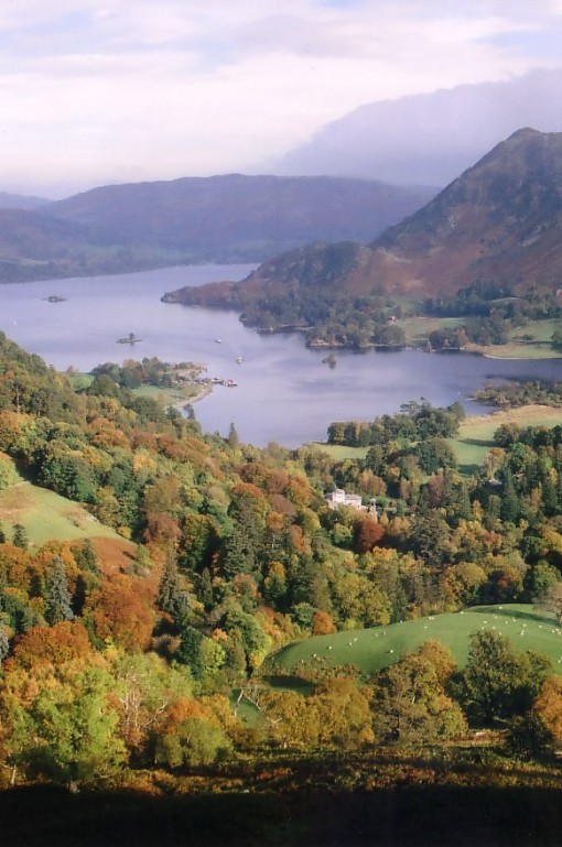
We were soon at the start of the very steep ascent of Birks and met our first walkers of the day – I resolved to beat them up the steep nose of the hill (I never change really). We set off up at a cracking pace, stopping occasionally to see how much we were thrashing the competition by – I’m pleased to say we were leaving them in our wake nicely! The autumn trees and the views back to Ullswater were really lovely…


Note to George Monbiot here and his blaming sheep-farming for the lack of scrub and trees on hillsides… all the areas in these photos have sheep year-round and there look to be quite a few trees to me! I think he’ll find, if he looks into it, that it’s actually weather and altitude which are the problems!
We soon branched off the normal route for a path directly up the top of the nose which Richard found last time (when I had my bad leg and couldn’t walk). He said the path had been pretty ‘exciting’ to descend and, with the steepness and airiness, I could believe it. Going up is fine but I’m not sure I’d descend it if the ground was wet (which it generally is). Here is the view from the steeper route anyway with our competitors staying below on the normal route…

On reaching the ridgeline it’s a longish but easy plod to the summit cairn on Birks – a summit probably only visited by Wainwright baggers.

We continued on the path to the col before St. Sunday Crag, passing through a pretty severe bog where our path joined the normal one under the face of Birks…

Looking back at Birks
We debated whether to rake across to Gavel Pike or just go for the straight ascent up the end of St. Sunday Crag and in the end decided on the latter. I couldn’t remember but hoped we could detour via Gavel Pike when we descended to Deepdale Hause but, in the end, was sorry to find that it would be too much of a detour and we should have included it on the ascent after all 😦
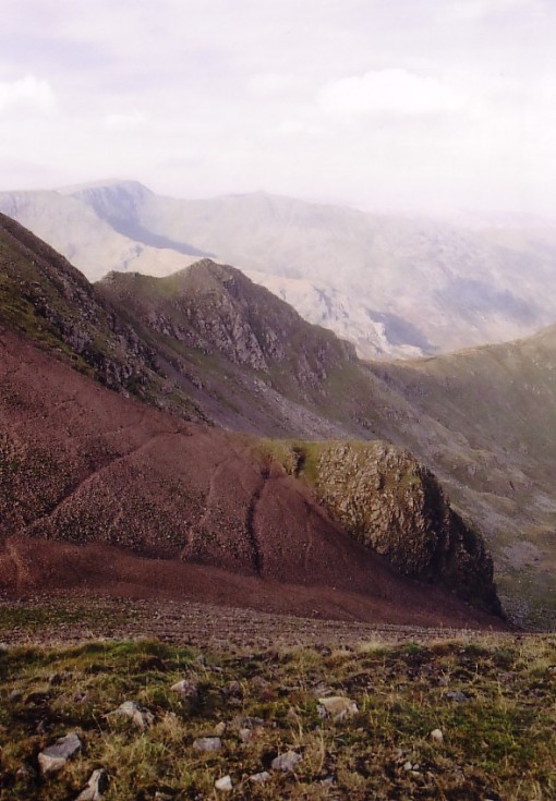
On reaching the summit ridge of St. Sunday Crag, we found our desired great views to the Nethermost Arete. As we found it was actually very windy on the ridges we were glad we’d abandoned plans to do that or the ‘Helvellyn Edges’. We each took a photo and I’ll put both here for comparison – my film photo first and Richard’s digi photo second – I like the colour and light on mine better but his is very detailed…


As Richard’s camera has a great zoom, I got him to take the most zoomed photo of the arete he could as we just couldn’t see a way up it – anyone know?

On studying the photos back home, although it looks too steep to be feasible, studying his other zoom of the ridge up to Helvellyn from the end of Striding Edge looks just as bad – and I know that’s absolutely fine!

R Wood
Dollywaggon Pike and its ‘Tongue’ (the ridge down the right-hand side of the peak) look spectacular from here – definitely a route I’ll be trying sometime soon hopefully…

We then set off down the easy descent to Deepdale Hause – looking back to St. Sunday Crag with poor, missed-out Gavel Pike out to the right…

Richard also took photos back to St. Sunday…


He also took this one down to Grisedale Tarn from the start of the steep (and slippery) ascent of Cofa Pike…

Cofa Pike wasn’t particularly nice on wet rock (my photo)

There was nice man just descending Cofa who gave Richard’s next shot scale…

both photos R Wood

One of my photos from a previous year looking back down from the final ascent to Fairfield…

After a quick mooch around the summit and a break for a coffee and flapjack, we set off for Hart Crag passing my favouritely-named ‘Flinty Grave’ on the way (my photos now for a while)…

Looking back to Cofa Pike across Flinty Grave – those must be sheep tracks as I don’t think anyone uses those routes – I’m tempted to try ascending up the gully sometime though…
We left Fairfield for Hart Crag with a vast multitude of people as we were now on the main route around the Fairfield Horseshoe… one seemingly oblivious child with a walking pole kept crossing my path repeatedly and nearly tripping me with his pole – I was starting to feel like showing him a closeup of Link Cove down the crags. When we used to walk with our parents as kids, they would never have let us behave so badly…

(no idea how I managed not to get anyone on my photo!)
From here-on, the walk became very bad for a while. I made the rash decision to take the ‘proper route’ from Hart Crag down to the col before Hartsop-above How – what a mistake to make! I wouldn’t advise this route at all in anything other than bone dry weather – the rock was lethal and we had to use hands (and bums) for the whole way down to the col. Everyone else was doing the same so it wasn’t just us being wusses.
My normal route is to descend the Fairfield Horseshoe route to the grassy col between Hart and Dove Crags and then turn left down easy grass to backtrack slightly to the aforementioned Hartsop-above How col. I once saw a weasel while I was descending that route – very high for such a creature I’d have thought!
This awkward descent ended up wrecking my legs for the rest of the walk unfortunately and I ended up having to borrow Richard’s pole for the final part of the descent to the road – good job he was feeling fine and well! Richard took this photo back up from the foot of the slippery slabby stuff but it doesn’t look particularly difficult in the photo.


Richard’s photo of the onward route to Hartop-above How in the evening sun
I’m always impressed by Greenhow End, especially since I once descended that way. I don’t think many people descend that way as they possibly think it’s impossible due to the reputation of the fierce terminal crags. However, as you can see from my photo below, there is an excellent route at least down into Link Cove by following the ridge to the top of the aforementioned fierce crags. At that point, you rake easily back into the cove on grassy rakes. Descending out of the cove to Deepdale, however, I found much more difficult!

Looking back to Hart Crag and Fairfield…

Approaching Hartop-above How – another walker at the summit kindly lending scale to my photo…


Gill Crags? near summit
We both took the following photo but my camera won 😉

The sun went down undramatically (looking back)

After this point I didn’t take any more photos as the light had become too dim for my film camera really – certainly if I wanted much colour. Richard’s digi-camera continued to capture decent colours so he took over as photographer for the rest of the post starting with this nice shot of Brotherswater just appearing…

There were a few clambery and rocky sections on the descent from Hartop-above How which my legs would no longer cope with so I had to continually resort to lowering with my hands 😦


he took a couple of photos of this nice rock garden for me

I have to say that the following photos would have looked horrible on my film camera but his still managed to turn out reasonable results (I still don’t like digital though 😉 )


especially this one!

Soon after this, we descended back down to the hard road where the following couple of miles pounding back along it finished my legs off completely. It didn’t help I was having a race with a family who thought they could thrash us oldies though! 😉

Lovely photos there Carol! I think I did some of that route, at least I remember the scrambly descent from Hart Crag – both times have been in lovely weather so I agree it would be horrible in rain. I am really looking forward to revisiting the Lake District again – hopefully this year.
LikeLike
It wasn’t really raining though – I think it was just wet from the night before or something. It was quite a nice day while we were out. Not sure why it was so slippery but that rock was really greasy!
LikeLike
Nethermost Arete looks spectacular, will have to venture there one day. The child with the walking pole had a lucky escape, I bet you were very tempted to give him a detailed look at Link Cove.
LikeLike
I couldn’t understand what that kid’s parents were thinking – we’d have been snapped at by our parents and soon returned to heel!
LikeLike
It was the same when I was a kid, I had to behave!
LikeLike
A nice round 🙂 I’ve done the Nethermost Arete, quite a few years ago but can’t remember it being difficult – still got the Tongue on Dollywagon to do. With the road closures might have to wait a little while longer!
LikeLike
A long way round but you could get there via Ambleside/Troutbeck still I think? I’m keen to do Dollywaggon Tongue soon – maybe I’ll try to combine it with the Nethermost Arete. Can you remember if you stuck close to that big drop on the right? or kind of went left across grass and then made your way diagonally back towards the edge through those broken crags?
LikeLike
The A591 is closed on Dunmail so Ambleside is out! My usual route is via the A66 Troutbeck to Glenridding – I presume that is now open? Although Glenridding is pretty smashed up 😦 We went up Striding Edge and came down the Nethermost Arete – think we just stuck close to the rim (the right) and followed the ridge down then deviated to look at the old mines on Eagle Crag. Sorry it was pre-digital so no pics.
LikeLike
That would be my usual route too. I think the road is shut between where you come down from Dockray to go along Ullswater shore to Glenridding isn’t it? If it opened, it’s probably shut again now after the new rain 😦
You went DOWN Nethermost Arete? 😮 Very brave from what we’re seeing on that photo! I’d like a look at Hard Tarn close up 🙂
LikeLiked by 1 person
“Non exciting” and “The Lake District” in the same sentence. Tisk Tisk. What would Wainwright say to that? .I’ve always had more excitement down there than up in Scotland for the last few years. You must be doing something wrong :o)
LikeLike
Well of course, what I mean by exciting, is the usual account of things going badly and descriptions of the various ‘epics’ I have in the Scottish hills which people enjoy reading so much. I’d say the Lakes hills are ‘restful’ and that’s how I like them.
LikeLike
Nice post. Done most of these but yet to do Hartsop above How.
LikeLike
That’s usually a descent peak – you could include it either coming down from Fairfield/Hart Crag or also with a round from High Hartsop Dodd.
LikeLike
You do seem to have a lot of nice weather on your wanders, Carol….. 😉
LikeLike
I think it’s more a case of those being the ones I blog about. The horrid days also get a mention if they’re epic enough but that’s generally Scotland and not the Lakes.
LikeLike
Nice rock garden 🙂
LikeLike
The Cofa Pike ascent bit? It’s just a mass of boulders all the way up – great in the dry but they’re very slippery boulders in the damp.
LikeLike
Some cracking photos there….
LikeLike
Thanks 🙂 it was a pretty good day out
LikeLike
Stunning pictures!
LikeLike
Thanks John – it was a pretty stunning day really apart from being very windy…
LikeLike
Wonderful report Carol! Good looking country. Nice to see you study photos for a route. When I was a youngster we used to hang around at the bottom of mountains waiting for evening light to turn just right to cast definitive shadows, allowing us to see a route. Lovely photos. Bob
LikeLike
The evening shadow method must be a pretty good one. I think I’m going to have to have a bimble up to the foot of that ridge and see what’s what!
LikeLike