18 Aug 2007
These two walks both have the same start and share a lot of the same scenery so this report starts out describing a traverse of the mountains on the west side of Glen Rosa and beyond to the road just north of Sannox. The second walk we did was a delightful little round which branches off after the second peak, Beinn Tarsuinn and is suitable for a half-day walk – a great one to do the day you arrive on the island if you’re feeling up to it!
On the first trip I took with Richard to Arran this was the first walk we decided to do. We’d left the car over at the ferry terminal on the mainland as we intended to use the great bus service which runs around Arran during our trip. This had the advantage that we could do ‘traverse walks’ as well as ‘rounds’ if we so desired – this day we did so desire.
We’d obtained a bus timetable on arrival and noted that we could set off in a morning from Brodick to walk from Ben Nuis along the west side of the ‘H’ of the main mountain range and end over the peak of Caisteal Abhail. From there we had a choice of descents back to the bus route round the east side of the island. We could either descend the normal route along to Suidhe Fearghas and get the bus from there or keep heading north on another ridge to Lochranza. We delayed the decision until we were on Caisteal Abhail where we eventually decided to do a variation of the normal Suidhe Fearghas route as we found we couldn’t do ‘The Witches Step’.
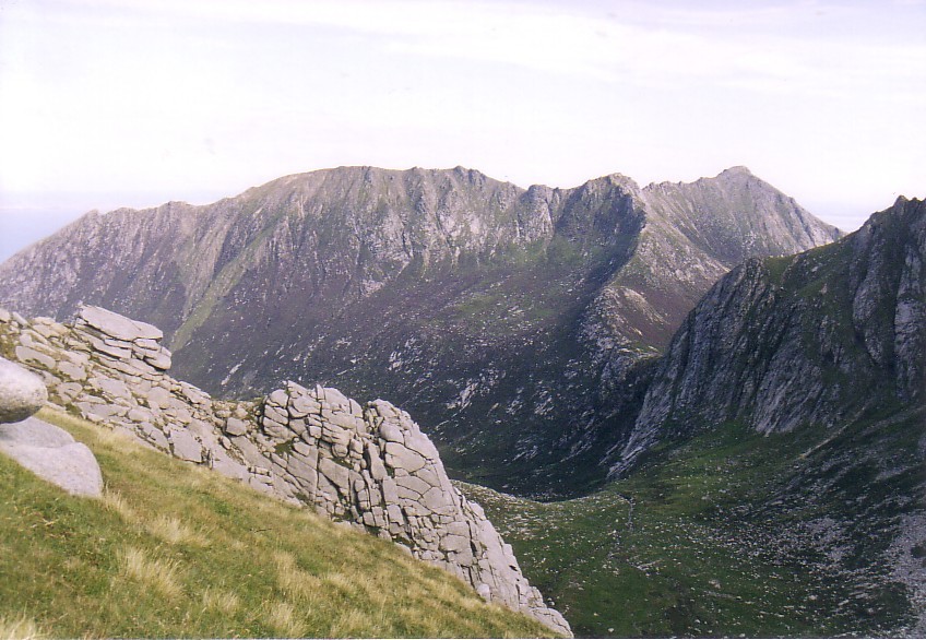
We got off the bus at the start of ‘The String Road’ just outside Brodick and, after walking a hundred yards or so up The String Road, we turned right down the road into Glen Rosa. After leaving civilization behind, in Glen Rosa’s case just a few houses, the glen bends left past an area used as a campsite. The path continues along the river bank for around a mile and a half to where the glen bends right and a burn comes down the hillside on your left under a footbridge.

The bend in Glen Rosa
We crossed the little bridge and then turned directly up the hillside on our left on a small path. After a short, steepish climb there is a huge, long area of bog which takes you, after another mile or so, to the foot of the climb up Ben Nuis.

The climb starts easily up mixed grass and slabs to a shoulder when you then turn right to head north up the steep grassy pull to the summit. The route then basically heads north all the way from there to Caisteal Abhail.

Richard soldiering up the final steep ascent of Ben Nuis – poor old man! 😉
From there the pleasantly narrow ridge wends its way to Beinn Tarsuinn – an absolutely cracking route.

There is then a steep, slabby descent past the superb ‘Consolation Tor’ (where the two routes in this report diverge) to the col before A’ Chir which, when Richard saw it, was keen to try to get onto.

Consolation Tor – where the two walk routes diverge…

The Onward Route Along the Ridge

Looking across Glen Rosa to Goat Fell
After Richard had unsuccessfully tried to ascend onto the initial ridge of A’ Chir, he gave up and joined me for the traverse under the west side of the peak.

Traverse Under A’ Chir Looking Back to Beinn Tarsuinn Descent
We then headed for my favourite peak – the very spectacular Cir Mhor…

The ascent up the back of Cir Mhor is straightforward but steep and the summit is small but superb with great views down Glen Sannox.

Glen Sannox (Witches Step is on the left)
After a break and a good look at the views, we then descended equally easy ground to the next col before Caisteal Abhail.

The ascent of Caisteal Abhail is yet more straightforward walking round the edge of a scoop with further great views across Glen Sannox. The summit ‘Castles’ looked very daunting on approach but it soon transpired that, by passing them, there was another easy route up onto them.

Looking Back to Cir Mhor and the walk so far…
The other side of the ‘H’ – Mullach Buidhe (L) to Goat Fell (R)
The route then takes a turn to the right along the ridge towards the famous and daunting ‘Witches Step’. This ridge was pretty scrambly and rocky but I didn’t find anything to unduly perturb me… that is until we reached the step.
I sent Richard down to scout it out but he ended up coming back up after being marooned above a drop he couldn’t see any way of reversing if it didn’t work out below that. A little way back along the ridge, I’d noticed there was an escape route to the north on grass so we ended up taking that. We came off the ridge just below the ‘Step’ but didn’t bother climbing back up onto the ridge to do Suidhe Fearghas but just continued out to where we found a good track leading back to the road and the bus.

The Witches Step and our escape route grassy rake (sunlit at its foot)
I’ve been asked how long this route took – we didn’t take much notice but I think it was around 6 hours…
October 2008
Our second walk, as mentioned earlier, diverged from the first walk at Consolation Tor on the descent from Beinn Tarsuinn. You should take a short detour up onto the Tor before heading round its southern side to find a nice little path which descends to the col before Beinn a’ Chliabhainn. We were amused to find a natural (short) rock tunnel going round below the tor! 🙂

When you get to the col, look round behind you – there’s a truly spectacular view of the Meadow Slabs, Consolation Tor (which looks even better from here), and the Bealach Fhir Bhogha across to A’ Chir and the Pagoda Ridge climbs.

(Our descent followed the right-hand skyline)

A’ Chir Looking Mean
On the way down to the col there is a very exciting looking tiny path cutting across to the aforementioned bealach. I’m trying to pluck up courage to have a little explore along it (I’m sure Richard will give it a go). The path is probably about 8 inches wide and over some pretty severe and almost vertical crags with a pretty large drop to Coire Daingean below! If anyone has given that track a go, put a reply on here and let me know what it’s like!

Exciting Route!

Looking ahead to Beinn Chliabhainn (above) and back again (below)

When you’ve had your fill of the view there’s a very easy climb up onto Beinn a’ Chliabhain which has a surprisingly narrow and slabby summit ridge. We clambered all over it and tried to stay on the ridge as much as possible but it was quite tricky in places. I also found a lower ledge above the very large drop into Glen Rosa but even Richard thought that was a daft route and left me to it.
When you finish the narrow summit ridge I’m afraid any excitement is over for the rest of the walk and all that’s left is to descend on a good path down easy slopes back to the bog above the initial climb up the first burn and the nice walk back out of the glen…
Looking back…


We took the opportunity to sunbathe on a slab in the (pretty raging) river as it was a nice hot day 🙂


How long did the second route take you?? I’m was hoping to do this Friday but weathers looking maybe not recommendable? I also have 4:30-9:15pm (sunset) tomorrow (Thursday, sunny!) that I could do. Im in Arran for a wedding late afternoon Thursday -Sunday morning and have been researching wanders extensively. I have all the kit, but am not a mountaineer proper -no harness etc.
LikeLike
You won’t need a harness – it’s just a bit of clambering around. There’s nothing scary on it. I’d say we took probably 4 hours but you’re probably best to allow nearer five if you’re not that experienced. I see you have nearly 5 hours available and would think you could do it in that time.
Not sure how good your navigation is but, if it clags in, it will take you longer than if you have beautiful conditions like we had. I’d say the best advice is to use the steep/vertical right-hand side of Ben Nuis and Tarsuinn as a handrail if it’s misty (there are paths). When you get to Consolation Tor in the photos above, you need to go ‘over the edge’ as it were – it’s no longer vertical (or even steep) at this point – you do that on the nearer side of the tor. If you see the mini rock-tunnel soon after the tor, you’re on the right path – you go though it.
From then on, you’d have a steep escarpment on your left all the way to follow. When you’ve gone along the top of Cliabhainn, you basically continue in the same direction back to the burnside (there is a path) and then follow the burn back down to Glen Rosa.
LikeLike
Just came across this old blog post while searching for something Arran related. I read about the ‘exciting path’ above Coire Daingean. I have tried this path and it isn’t for the faint hearted! When I tried it there was some pretty major erosion going on – one small section of path had slid away a bit and what was left was angled firmly in the downwards direction. I moved over it quickly and tried not to look down as I contemplated the stability of the soil underneath my foot and wondered whether any animals or people had been on that bit when it slid or whether it happened during a storm!
I’ve had worse moments up on the hills but surprisingly most of them don’t seem to have stuck in my memory as much. I think that normally in dangerous situations I feel more in control of myself but on that path I felt as though I was really at the mercy of the soil beneath my feet. I think my companions felt the same.
LikeLike
That sounds damn scary! If it’s crumbling away, I think I’ll probably give it a miss. I might just set out along it to get a flavour of it and then turn back! Thanks for the info – nice to find someone who’s braved it!
Carol.
LikeLike
Hi Carol. I hitch-hiked to Skye with a mate in 1976 and on the way back we passed across Arran. We were only there a day and my memories are very vague. I didn’t realise what fantastic scenery there is. That is absolutely spectacular. Must visit there sometime.
Cheers, Alen
LikeLike
I honestly think that Arran has just about the finest Scottish Island scenery there is! There’s quite a bit of variety too – I also liked Machrie Moor – very atmospheric – and many of the long glens between the mountains. It’s also great that you don’t have to take a car if you don’t want to.
LikeLike
Great post Carol, with great pics to match 🙂
LikeLike
Thanks Paul – probably ‘cos it’s a great island! 🙂
LikeLike
Hi Carol. My favourite Scottish Island. The puzzle is why I’m not over there more often as its on my doorstep but maybe I don’t want to ruin the magic with overfamiliarity. Some great photos of the ridge. I never bother with times either as its just a distraction. I’ve met folk that time themselves to every summit they reach though and write it all down. It seems to be highly important to them for some reason. Whatever floats your boat!
LikeLike
I like to know roughly how long a walk took so that I’ll have more idea how long a similar one will take. Also people often ask me how long they’ll need to do a walk I’ve done so I’ve started taking a bit more notice of the total time.
I have to admit to being a good guesser when asked to say how long I’ll be on a route though, if I’m getting dropped off and picked up later for instance. I seem to just pluck a figure out of the air within a minute or so and am accurate to 10-15 minutes or so. Mind you, that could possibly be that I walk at speeds which will get me back in that time frame I suppose…
LikeLike
Nice, sunny photos for a snowy, winter’s day! We’re hoping to visit some of the Western Isles this Easter, having never ventured over that way before. They all look very tempting!
LikeLike
Hi Chrissie – I was going to put out a frozen and snowy one but this report was a special request from Fedup below! 🙂
LikeLike
What a great read (you write so well) and the photos are superb. I really enjoyed this post and I am taking great delight in slowly reading through your old posts. So glad I discovered your blog!
LikeLike
Why thankyou 🙂 I have to say my blog is probably more about writing than photography – I take some good images but many of the rest are mediocre and some are only taken to illustrate sections of route anyway.
LikeLike
Great report Carol & some fantastic photos that show the ridge & the route excellently 🙂
Its interesting to see the two routes on Beinn Tarsuinn together, both look worth a visit. If you returned to the island which would be your favoured ascent route, Beinn Nuis or Beinn Chliabhain ?
Thanks for taking the time to share 😀
LikeLike
Hi, my favourite ascent route would always be up Beinn Nuis and that second walk, the little round of Nuis to Chliabhain is my favourite walk on the island I think.
BTW, I’ve added a new category to make searching for Arran reports easier – it’s a ‘Scottish Islands’ category. I haven’t put the Outer Hebrides in that group though – I’ve left them in ‘Hebridean Walking’. Things like Skye and Mull will have both categories attached to them.
LikeLike
Thanks, I noticed the new category 🙂 I would have come across your other Arran reports eventually ! Skye is a walkers paradise 🙂 – I’ve only done the touristy bits on Mull but its hills are somewhere on my ever increasing list 😉
Have you had much snow in the Dales ? Seems to have missed this corner of Cumbria 😦 although ‘Snowmageddon’ is over yet 😆
Cheers Simon
LikeLike
I prefer Mull to Skye for hill-walking and want to do a lot more there.
We’ve got very little snow here – I’m still laughing at the ‘Snowmageddon’ tag the newspapers gave it though – what a fuss!
Up in North Lakes soon – Braithwaite 🙂
LikeLike
Wow, beautiful shots.
LikeLike
Photos are wonderful! Thank you for sharing!
LikeLike
Thanks both of you – I have to say that the mountain scenery on the Isle of Arran is so beautiful that, in good weather (which we were lucky to have on our visits), it’s almost impossible to take bad photos I think.
LikeLike