Mon 9 Jun 2014
As Richard was out with me the day before, and no longer does two days in a row, I decided to go off round the peninsula of Glenelg to pick this top off. I also decided it would be a lovely spot to drop Richard off to amuse himself – he ended up visiting the pub at Glenelg, having a good look round the village, and a walk down to the ferry jetty to take a quick trip across to Kylerhea on Skye. The weather was beautiful – hot and sunny…
Click on photos for full size/resolution
I drove around to the furthest edge of the first large forest at Mam na Staing where a good forest track sets off east for Loch na Lochain – an ingenious name I’m sure! The forest track is around two miles so you can make rapid progress towards the hill. You also occasionally get a quick glimpse of it – it looked vertical and forbidding to me! We didn’t see the hill when we did it before and Richard was taken ill in the bad weather during the steep climb to the summit so I didn’t really have happy memories of it…
Incidentally, this track could easily be cycled, saving you four miles of walking if so desired. The start point is a good few hundred feet higher than Arnisdale too 🙂
In forty minutes, I arrived at the little 3-sided hut Richard and I had used on our return last time to shelter from the weather to get warm drinks. The hut marks the edge of the forest and the start of the bog – there is the pretty Loch na Lochain to look at though and it makes a great foreground for photos of Sgritheall.

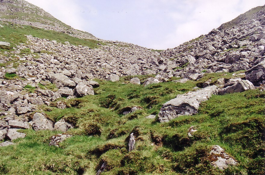
You can head either side of the loch so I picked a route to the west and south on the way out. This turned out to be horribly wet so I determined to head straight across east and north of the loch for the hut on the return (as we did before). I headed up onto the low ridge of Creag an Taghain and followed it pathlessly across rough ground to the small lochan at the start of the path up Sgritheall’s steep west ridge.

Looking Back…

I’d been studying the hill during my approach and was musing about leaving the main route in a small, shallow corrie between the main Munro summit and the NW top. There was a very bouldery stream to follow upwards but the angle looked much less steep and it looked okay. There were also quite a few grassy patches which I could try to patch together to avoid the boulders as much as possible – it wouldn’t be totally possible though.

The sun was beating down and it was quite hot but it was lovely and clear so I wasn’t complaining. I was thinking back to the first time we’d done the peak when we’d had a terrible time getting up onto the west ridge from near Arnisdale. I can’t remember whether we found the marker cairn for the path up the steep, craggy and very rough side or not but we certainly didn’t manage to follow it. We had an hour of flogging up steep and loose rocks, craglets, heather with holes in it, boggy bits and, by the time we reached the shoulder, one of my hands was pouring blood from handling sharp rocks! That was when I studied the map on the shoulder before our return and decided we were heading out on the simple forest track and walking the three or four miles back round the road to the start!
I was therefore pretty surprised to find two guys getting it even more wrong than we did up ahead! They’d flogged up the extremely steep and loose side to join the ridge about half-way up – one of them looked totally knackered… But it was my turn to surprise them, and two guys descending above us, however when I turned off the path and headed for the bouldery burn between the two peaks! They all looked suitably bewildered…

I turned off here…

Instead of slogging up here!
I headed across easy grass to the burn and was pleased to find it was flowing quite lustily above ground at that point and could therefore be drunk from. I did have my coffee with me but, on such a hot day, I prefer nice, cool water – I scooped a flask-cupful out and drank it eagerly – lovely!
I headed off up various grass patches above the burn but it wasn’t great going and I often had to tackle small boulderfields instead. I was soon very out of breath and feeling a bit knackered myself. No matter – I could see it wasn’t far to go to the col.
When I reached the col, I was surprised what a beautiful grassy hollow lay between the various peaks. My NW top was up very easy grass and not far away – there was a NE ridge which curved round north and then west to the bog I’d come up from. I’d originally been going to descend that way but it was quite a bit longer and, Richard not having all that much to do at Glenelg (apart from perhaps booze in the pub!) I decided I couldn’t really extend my walk around it. I decided to head back the same way after a break.

NE summit from NW Top


Munro from my top
I had a little fight with myself while I drank a coffee and munched a fruity, oaty-bar to try to persuade myself to add in the main Munro peak and descend the normal route. In the end, three things put me off. General laziness/lack of fitness, the lack of a path up the boulders to the summit, and the realisation that, in missing the main summit, I was only behaving the same way as folks missing out the NW Top! I know we also missed it out originally but we did the Munro in horrible weather – rain, clag and a freezing gale – and Richard was pretty sick by the summit.
Decision made, I happily headed back down the burn of boulders – they were actually easier in descent for a change and I found sticking as far as possible to the burn itself was easier and provided more grass – it was quite fun really. You did have to be careful you didn’t fall through a weak spot into the underground burn though!

The route in from the descent – through the forest to the coast
Before leaving the delightful re-emerged burn, I had another good cupful of water and rejoined the path – still being watched in amazement by the two guys who were doing the main Munro – they probably thought I was nuts and had missed the summit…
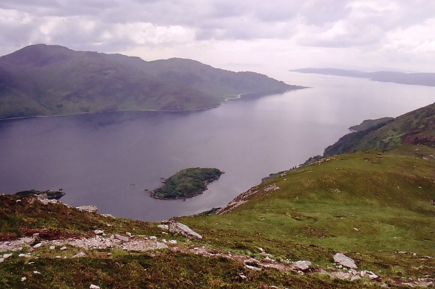
Loch Hourn from Descent
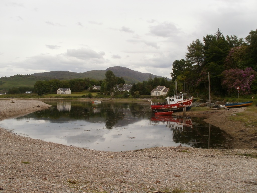
The route past the loch on its eastern side was much quicker and quite a bit drier than the outward route and I was soon back at the hut and forest track. I ended up taking a full hour less than I said I would and surprising Richard just as he was heading to look around the small church in Glenelg village. We adjourned to the pub and then, rehydrated, I decided to drive us round to the ferry jetty as Richard had seen seals there…
Richard’s photos from Glenelg:

Beautiful pub garden


The Old Barracks


The Turntable Car Ferry – operated by hand! – for people who can’t reverse apparently…


Lovely Seals 🙂

Stats: 2864 feet of ascent, 8.5 miles, 4 hours

What have you still to do on Skye Carol ?
LikeLike
The rest of the Munro Tops – Basteir Tooth (which I want to do via the Lota Corrie route but my current guide doesn’t so I’ll have to do it next year now I think), Banachdich’s tops either side, the dreaded Ghreadaidh’s South Top! :-o, Sgurr Sgumain and Thearlaich (Thearlaich was described by my guide as ‘short and nasty’), Sgurr a’ Fionn Choire (looks nice).
LikeLike
The Bhasteir Tooth via Lota Corrie is nothing to worry about,Sgumain is easy,The hard part getting onto Thearlaich is getting off the ground at the top of the Great Stone Shoot.It`s only a couple of moves with no exposure though.
If I`m finished my Corbetts by the time you go I may join you as I feel a bit guilty about missing your last Munro 🙂
LikeLike
I’m going in August! But the Bhasteir Tooth will no doubt be next year. If you and/or Bob came with a rope, I could dispense with a guide for that one! 🙂
Thanks for the info on Thearlaich – that’s what I like to hear. It looks okay on the photos now I’ve started doing some climbing. I was doing some limestone climbs the other day for the first time – 3 Severes – 2 grades harder than I’d done outdoors before. I was a bit slow and needed people to shout up when I got stuck to point out footholds but managed in the end 🙂
LikeLike
That all looked rather nice and I love that ferry!
LikeLike
Glenelg is lovely but I have to say I don’t enjoy the drive over the pass – I believe it’s just as bad from the Skye end too – I’m a steep road coward too! 😉
LikeLike
Another interesting read, Carol. I’ve often seen Beinn Sgritheall in the distance from other peaks but I’ve never actually been up it – never mind the North-West Top. It’s a fine mountain, especially when viewed from Knoydart.
I spent half a day queuing for the Glenelg ferry once, before the bridge was built. Ah, happy days.
Cheers, Alen
LikeLike
I have to admit I always went on the Cal-mac ferry from Kyle anyway, even before the bridge – they were pretty frequent.
Beinn Sgritheall is certainly a stand-out peak in that area – very imposing. It’s quite a nice walk if you do it via the forest route I use instead of the book one. It’s certainly a lot less height gain…
Carol.
LikeLike
Well I’m consumed with envy. Done the aforementioned hill twice and never seen a chuffin thing. It sure looked good when I did the adjacent Graham on Easter Sunday.
How many Munro Tops left now?
LikeLike
42 as of last (exhausting) week…
We certainly didn’t see anything the first time we did Beinn Sgritheall but I was very, very lucky with the weather that day – not too hot but lovely and clear and sunny. Makes a change for me in Scotland!
If the Graham next door was Beinn a’ Chapuill (spelling?), I’m wanting to do that, it looks a great hill!
LikeLike
Nice photos and useful route info as usual 🙂
I travelled on the turntable ferry a few years ago when leaving Skye, I regret not stopping to have a look around Glenelg.
I think I got a rare sighting of the Mountain Coward at the Whitrigg junction by the LDNP boundary stone yesterday afternoon, just as the rain started to pass over. Didn’t think you would appreciate a blast from my car horn but I did wave!
LikeLike
Was I with my little fold-up bike? I’d just nipped up Caermote so I’m sure you’re right! I didn’t notice a car particularly but I think I was getting pretty cold and wet so pedalling furiously…
LikeLike
Sorry for the double comments after 8 hours it still hadn’t appeared I presumed it had been lost somewhere in cyberspace! Looked like you where about to join the main road back down to Castle Inn, I think I was already past when I waved so you probably wouldn’t have noticed anyway! Caermote & St John’s are quite a good viewpoint over the Solway, and the approach to Binsey from there is worthwhile, I’m not sure why AW missed it!
Cheers Simon
LikeLike
I think you must have commented from your usual ID and another one as one comment was in the ‘moderation’ queue and you’re approved to comment any time.
Due to my almost total lack of ability to deal with long uphills when cycling, I always cut around the Bewaldeth road back to base as that loses the least height! 😉
LikeLike
Great photos & handy route info as always 🙂
I’ve used the turntable ferry before to leave Skye, wish I’d taken the time to stop at Glenelg, but it gives a good excuse to return!
I think I got a rare sighting of a Mountain Coward on a wee folding bike cycling by Binsey yesterday afternoon, just as the rain came in. Would have stopped but was running late 😦 and didn’t think you’d appreciate a honk of the horn!!
Cheers Simon
LikeLike
You’ve come out twice but, as your comments say slightly different things, I’m putting both out and replying to both 🙂
Yeah, would have been me that – I was getting pretty wet and thinking of my washing being out back at the caravan so I might not have appreciated being pipped at – I’m not good about car horns anyway as we get too many of them in our village when I’m trying to sleep off nights so I might have unthinkingly flipped you a V or something – sorry – just my usual reaction to car horns. It’s hard to make them sound friendly isn’t it?
LikeLike
Glad you got a good day for it Carol. It’s a great viewpoint. That old turntable ferry is amazing when one person can pull it around one handed full of cars. Great engineering yet Glasgow’s slim revolving tower in the city has had numerous problems and lengthy breakdowns using a similar concept. That’s progress eh.
(By the way I was commenting in a previous post about Janet Street Porter’s opening statement in her recent programme about Scottish independence which suggested that the only reason for separation was that we hated the English so much, a conceited viewpoint that took my breath anyway. If it is a yes vote in September (unlikely, but you never know) it will be for numerous, hopefully beneficial reasons (better prosperity, chance to set our own budgets for councils up here, choice to adopt or reject new implementations ( bedroom tax etc.) and not for any dislike of our near neighbours. A point I was trying to make as Scotland’s political choice at the moment is continually outvoted by a higher density population in the richer south of England under the current system. Maybe I didn’t express it well last time?)
Still your friend whatever the vote is… me :o)
LikeLike
Awww – good to hear I have at least one friend 😉
Janet Street-Porter was always a bit of a nutter though if you ask me! I agree with your point about the rich south – we in the north of England suffer just as much with that!
Carol.
LikeLike
Wonderful…I must get out into the mountains again – I have become something of a ‘moor bunny’ and it has been too long since I was up high. Your blog is inspiring and every time I read a post I want to get in the car and drive to Skye and ‘do’ a mountain. This place looks lovely.
LikeLike
We’re back on Skye in August and I’m not feeling confident this year – you’ll have to come to the Cuillin and cheer me on! 😉
Carol.
LikeLike
If I had the time I definitely would. I am sure you will do well and am looking forward to your posts and photos…
LikeLike