Wed 2 Sep 2015
Although the forecast was for a dire day all day – heavy rain and high winds from the north – I got up anyway and had a look out at 0830. After a quick walk up and down Ullapool to see which of the smaller hills were out, I decided it didn’t look too bad to the north after all. A quick breakfast later and the bike was bundled into the car for the 23 mile drive to the start – the access track to Ben More Lodge.
I was surprised on the drive north to be seeing the classic Sutherland inselbergs were out for the first time – Culs Mor and Beag were both out and most of Breabag. My hills, however, were in cloud…
(click on photos for full size/resolution)
I’d arrived and had booted up and built the bike by 1015 and started on the three mile track to the lodge. I was surprised at how easy the going was – it was almost flat most of the way and the track was tarmacked from the start of the loch onwards (not sure why it isn’t before that). I’d parked my Sunny where the track leaves the main road which, as the track is shared by the lodge and the Forestry Commission, was slightly worrying – I hoped no large logging lorries would need access and take exception to the car being parked there.
I tried cycling a further mile past the lodge where the landrover track was due to end but, after crossing a 2-plank bridge across a ford, found the track became too rough for my small-wheeled bike so I got off. There was nowhere to leave it so I had to wheel it quite a way further until I could find somewhere to put it off the track. I cabled it up, patted it and told it I’d be hours…

The first two of my three hills in the distance
The track passed through a deer fence gate and soon after there was a bridge over the river. There are two tracks here and I wondered whether to change plans and take the one which heads towards Inchnadamph and slog up steep grass to the col between the first two hills. In the end though, I decided to stick to my original plan and head onto the shoulder of Eagle Rock and ascend that hill first – it looked a nice hill…

The Inchnadamph track turns off – my peak is still in clag behind the second hill
The track was exceedingly wet and sometimes I had to hop up onto the bankings or I’d have been underwater – but that’s only to be expected this year and I’d certainly walked worse and wetter tracks. There were a couple more river crossings – the first of these I just paddled over on mossy and slippery rocks as it was shallow. The final one had another little bridge. The weather had actually been sunny so far but that was about to change.
The track then started the ascent to the shoulder of the first hill of Eagle Rock (Gaelic name Meall an Aonaich but I like the other name better) – I didn’t really notice the climb to the shoulder but could see the ridge of the hill was very long indeed. Near the highest point of the track there was a quartzite cairn and, soon after this, I headed off up the long ridge on short turf and pretty bell-heather.
Further up the grass got a bit rougher, the bell heather disappeared, sections became steeper and rashes of quartzite scree appeared. At one point I could see a cairn up ahead on a knoll. I hoped that was somewhere near the summit but, on reaching it, could see it was nothing like – not even halfway up – not sure what it’s there for as I couldn’t really see any path.
Later I saw a large, well-built cairn up ahead and hoped that was the summit. Again, it was nothing like and I could see much more hill up ahead – there was a line of cairns just here though and faint traces of a path. The angle eased and things became easier. The wind, however, started to really blow across the ridge here and, by the summit, it was quite fierce. I hoped it wouldn’t be blasting across the narrow ridge I had to do to get to the South Top!
There was an easy descent to a col before Carn nan Conbhairean but quite a bit of height was lost. Conbhairean towered above me looking very big and steep! I stopped and stared up at it then, suddenly, when I went to set off again, my worn hip caused my groin muscles to twang hard and I yelped pretty loud. I was worried my leg was going to stop working as it quite often does now my hip has suddenly become worn. I took it slowly until it warmed up again and, although it was no longer comfortable, it was managing okay.
Carn nan Conbhairean (doesn’t look big and steep in the photo)

Looking back to Eagle Rock from col

Breabag in a clear moment
Despite looking so hard an ascent, Conbhairean went pretty easily and was a steady plod – I was soon on the summit.

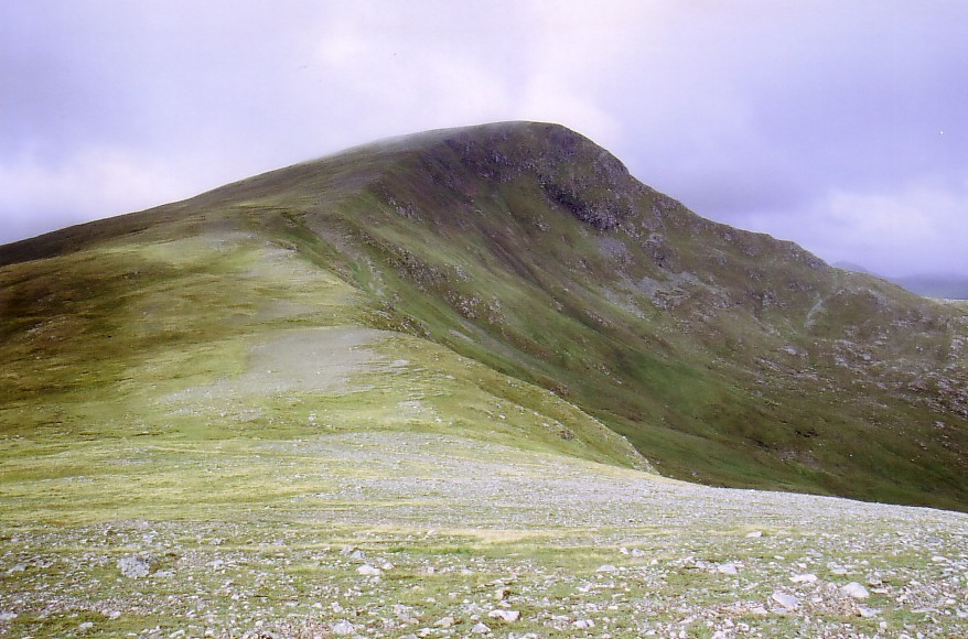
Ben More Assynt’s South Top Appears briefly
Here things were to start to get hairy! I could see the side of the descending ridge and could see it had quite a few humps along it – I hoped they were okay as it was still a bit gusty here and the rock was wet and slippery. The sun had pretty much gone now and the top of the hill was dipping in and out of mist and drizzle.

Tentatively, I peered over the edge of the first rocky descent – actually it looked okay. The right-hand side was fine – just fairly steep grass and not too far to the corrie – the left-hand side not quite so good as it was extremely steep. I ignored the left-hand side and clambered down easily…
The humps gradually got harder though and soon I was edging along a tiny and very slippery path with rocky sections on the left-hand side over the nasty drop. I started to become much less happy – without the slippery rocks I think I’d have been fine but the rock was really greasy.

Presently, I came to a very nasty-looking narrow set of rocks to ascend the next section. I suddenly recognised them as the photos my fellow-blogger Nicole had sent me the week before I set off. There really doesn’t look to be a way around them either side – they pretty much had to be tackled. The boulders formed a set of sloping ‘steps’ about a couple of feet wide and the tiny footholds I found at their edges were greasy and my boots threatened to slide off them. I got the best handholds I could (at least there was nothing loose) and set about scrambling up them. I was held back here by my irritated groin as I was trying to put my feet pretty much up to hip-height and my legs didn’t want to go there! Sometimes a knee had to be brought into use instead…
Here are my fellow blogger Nicole’s photos on a better day…


I didn’t look at the drops down the sides but they felt large and threatening and I was pretty uneasy but hauled my way up. I was very glad I hadn’t been descending them and decided I definitely wasn’t coming back this way! No idea how Nicole got down them!
Another of Nicole’s photos showing there’s actually space beneath you as well as at both sides! 😮

After some more uncomfortable greasy side paths above an even more threatening drop, I finally got down to a small grassy col. Here is where the nasty gully people use for descent after the south top when coming from Inchnadamph appears – it looked ‘orrid! I was glad I wasn’t going that way either.
Looking down the other side of the col into the corrie on the Glen Cassley side, I saw two men descending the steep grass of the corrie wall. At first I thought they might be deer stalkers – I hadn’t managed to get hold of the Cassley stalkers but was thinking I might be going back via that glen. After my slight scare down the ridge from Conbhairean I was now sure I was. On seeing they were just walkers, I decided I might take their route – I’d originally planned to use the East Ridge to descend from the South Top if I decided I didn’t want to retrace my outward route.

Ben More Assynt South Top – East Ridge on right

Looking back to Carn nan Conbhairean
The onward ridge up to the south Top was very steep and looked like it might be nasty in places – but, by now, it was much too misty to see really so I just set off up… There was a rocky boss ahead but it was easily bypassed on the left on grass. From there it was a very steep path up a narrow grassy nose but straightforward enough and not scarily narrow. This went on for quite a way and then there was a shorter grassy nose. Looming above that, however, was a dark shape with vertical sides. Thankfully, as I got nearer I could see a path went quite easily up the front of it and, on checking my altimeter, saw I was more or less at the summit. Sure enough, after getting up that section, I could see the ridge widened dramatically (as the map says the summit area does) and the path headed up easy grass to where the cairn loomed out of the mist.
I went slightly along the next part of the ridge (which had narrowed again) to check there were no higher sections or cairns hidden in the mist – there weren’t. I went back to the cairn and tried to see down the eastern edge to see how the east ridge looked. Unfortunately, I couldn’t see much of it and wasn’t sure how steep or easy it was so decided ‘better the devil you know’ and set off back down the way I’d come up.
After a non-scary descent back down the ridge, I peered over the edge of the col. Earlier it had been totally non-misty and I could see down into the corrie and all looked comforting. Now it was just swirling mist and looked fearfully steep, as things often do in a mist. Going by my early view of it being fine to descend, and knowing the two guys seemed to get down okay, I set off cautiously down the steep and tufty grass. I was soon down in the corrie with no problems and I sat briefly on a rock for a coffee – my first break of the day.
I knew I just had to head out along a wide, gently-sloping tongue and then I’d immediately hit the path through Glen Cassley back around the end of Eagle Rock. The going was fine until I started to descend the end of the tongue to the next level of the glen and then it became slippery, holey and awkward.
All the way down the steeper section I could see no sign of the path but, on reaching the more level ground, suddenly I saw it heading away in an exactly straight line… full of water! Oh well, my feet were already pretty wet once again so I sploshed off along it.

Sometimes a path…

Looking back along it to my descent
There were again sections where the path was too wet to be walked and the going was pretty slow. There was a crossing of the exit burn of the nearby loch where I fell off the final stones and fell in the water over my boot tops but, this year, I’m getting used to that sort of thing so just shrugged and continued.

Carn nan Conbhairean gone back into hiding
Eventually, after a mile or so, the path started to rise up around the side of Eagle Rock again and became stonier and better going. I’d been studying this side of the hill and thought it was beautiful – the nicest hill of the day in my book – but it wasn’t photographable as it was right into the light and all was grey and dull anyway so none of its features showed. Conbhairean was lurking in cloud now and the South Top hadn’t been properly out all day. It was also raining most of the time now too…
On reaching the quartzite cairn on the shoulder again, I stopped for another quick coffee. It looked a long way back to the lodge and my bike from here!

Raining again – the lodge is level with the faint distant hill

The descent was easy on the wet track as the ground was so soft and I was soon re-doing the river crossings. At the last one I found a German man at the start of the Inchnadamph track. He suddenly seemed to fancy my route and asked me what it was like. On hearing he was actually heading for Inchnadamph and had a huge backpack to carry, I advised him to continue on the track he was presently on. I warned him it petered out ahead though but to just keep on heading through the left-hand gap for the River Traligill. A long route for that time of the evening!
I then hared off to find my bike – always a tense moment hoping no-one had thrown it into the river or something. There’d been nothing to chain it to so I could only cable the back wheel up and prop it against a crag by the track. The bike was there – very wet but fine. I uncabled it and wheeled it most of the way back along the rough sections of track to the lodge. I’d been going to finish my coffee here but, on sighting the good tarmac heading out of there, I hopped on and rode quickly off.
Returning along the track was quite a bit more uphill than it had been on the way in and I couldn’t be bothered to cycle up any of the rises so I had to get off a couple of times and walk. It was still only half an hour’s cycling until my beloved Sunny hove into view – always a good moment!
Just as I was shoving the bike back onto the back seat of the car, I heard a heavy engine approaching along the track. Looking around I saw a large forestry lorry rumbling towards me – luckily, I saw there was actually plenty of room after all and he didn’t shout at me or anything…
There is a roadside motel and bar about three miles back towards Ledmore Junction which I made use of to get a rehydrating pint of lime and soda and get my feet dry enough to put my trainers back on. Everyone in there, when they heard where I’d been, asked if that was my car on the end of the lodge track – I guess no-one parks there normally – not sure where they do then as I couldn’t see anywhere else. It was nice to sit down and relax!

The rivers were raging again on the way back!
Stats: 19.5 miles (6.5 cycling), 3891 feet of ascent, 7 hours 15

Its satisfying when the weather is better than forecast :), that river is a another route stopper in spate 😦 Do you think you will finish this year with this recent good spell or is it more likely to be next year? Cheers Simon
LikeLike
Nope – unfortunately my compleation will have to be at least next year now 😦 All due to the weather this year and particularly that week.
Carol.
LikeLike
I made be slightly strange but I like days like that. As long as the weather is good enough for me to get lost, the landscape seems more magical and mysterious.
LikeLike
Some guys were just discussing that point in Braemar last night – how the clouds make it all the more interesting. I realised they’re right – it sometimes complicates navigation though and I’m not a great or confident navigator unfortunately.
Carol.
LikeLike
So which ones do you have left? What are you saving for last?
Nice report, though I don’t like the look of that scramble at all!
LikeLike
At least the scramble was very short – just wish it had been less slippery on that ridge though – I’d have been fine in the dry I think – I just hate greasy rock!
I’ve got 6 left now. Sgurr nam Forcan (which I’m dreading), Lord Berkeley’s, Corrag Buidhe and the Eastern tops on An Teallach, Sgurr Dubh on the end of Mullach Coire Mhic Fhearchair and the eastern top of the Beinn a’ Bheithir horseshoe. The only one I’ll get done now this year is the latter so it’ll all have to be next year now.
LikeLike
Hello Carol. Very fine report. Do you ever hike in dry conditions? 🙂 Wonderful pictures as usual. It is pouring rain here. Normally I would stay off the mountains, but you’ve inspired me – I’m heading out. I’ll be wet and cold in no time! Take care out there! Bob
LikeLike
Funny you should ask that – we’ve just had a completely hot, dry and sunny week for my mountain-bagging in the east of Scotland 🙂
LikeLike
Thats good ! We are back in the mountains next week and we will be in snow. It is the end of the season and my boots are low on tread, but too late to break a new pair in. It should be fun. Looking forward to your photos of the Scottish mountains. Bob
LikeLike
Interesting route that, Carol. I didn’t know there were any dodgy bits on that ridge. I was going to use it as a decent route once but decided instead to retrace my outward route over Conival to Inchnadamph. Beautiful wild countryside up there.
Alen
LikeLike
In dry, non-windy weather, I’d say the only dodgy bit is the bit in Nicole’s photos – that was pretty airy and scary! Of course, the section I didn’t do, from Ben More Assynt’s South Top onto the main summit is far more scary apparently – I couldn’t see that for the mist though.
LikeLiked by 1 person
Brought back some good memories Carol. Only climbed that hill once many years ago (1980s) then explored a section of the underground river system before it got too exciting and hard for us with our inadequate head torches. It was only when I got my photos back in the caves taken with a flash that we could see how close we were to the edge of a large drop where the river plunged further underground. You live and learn… if you’re lucky.
LikeLike
Eek! that sounds scary. I’d like to have a look in the caves and know you’ve got to be careful as there are dangerous bits. I’ll be extra careful when I visit them after reading that though!
LikeLike
Looks very wet and boggy Carol. Great photos and a superb post (I am wondering why I hadn’t spent more time in Scotland when I was able). I flirted with it a bit years ago (once on a ‘whisky drinking expedition’ with some friends to Skye – where I fell out of a tree and broke my ankle – I was looking for eagles – don’t ask). I always enjoy your posts and look forward to your adventures….maybe one day when my knees are sorted I’ll get there again…
LikeLike
Love the sound of the ‘whisky drinking expedition’ and falling out of a tree LOL – wild adventures indeed!
LikeLike
It was a very long time ago…😁
LikeLike
I’m positive I passed some sort of carpark on the road past, but maybe I was thinking of somewhere else…
The route looks good, not many more tops now?
LikeLike
12 left unfortunately – should have been 8 by now but the weather that week put me off 4 of them 😦
I drove along the road in each direction and I’d say there was a parking place nearly a mile to the east of the track end – maybe that was the one you were thinking of. But I couldn’t be bothered to drive past and cycle back so used the end of the track. There’s a slight pull-in by a little hut on the road end but I thought the estate would be more likely to be upset if I parked on that and they wanted to park by their hut for something. The road-end for the lodge is very wide indeed – I was just worried about logging lorries.
LikeLike